Powerful weekend storm to impact millions across eastern U.S.
 Powerful weekend storm to impact millions across eastern U.S. (Photo: Getty Images)
A powerful weekend storm is expected to impact an eastern part of the United States, affecting an estimated 180 million people. Heavy rain, strong winds, snow, and severe thunderstorms will hit the region, according to AccuWeather and New York Post.
The storm's intensification will be postponed until it progresses from the Mississippi Valley to the Atlantic coast, where it is likely to gain strength and have a substantial impact, according to AccuWeather Meteorologist Joseph Bauer.

(FOX Weather screenshot)
Widespread heavy rain
Starting Friday, a widespread area spanning from the Gulf Coast to the Great Lakes and extending eastward toward the East Coast is likely to experience moderate to heavy rainfall. The potential for flash flooding is a great concern, initially along the Gulf Coast and parts of the mid-Mississippi and lower Ohio valleys on Saturday. The threat will shift eastward from the Florida Panhandle to the mid-Atlantic and much of the Northeast on Sunday.

(AccuWeatherscreenshot)
Strong winds
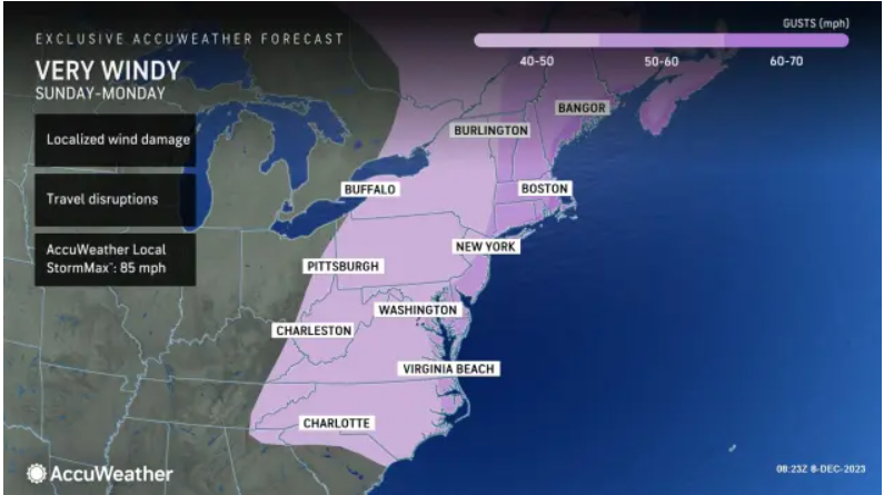
On Saturday, gusty winds are forecasted to develop over parts of the Rockies and Plains due to a sharp pressure difference between a wavy cold front and strong high pressure over the interior West. Wind gusts ranging between 30 and 40 mph are expected in these areas. By Sunday and potentially extending into Monday, strong winds are predicted along the mid-Atlantic and New England coasts, with gusts reaching 50 to 70 mph near the coast. These wind speeds could lead to significant travel disruptions at major airport hubs and raise the possibility of power outages across multiple states.

(AccuWeather screenshot)
Where snowfall is expected
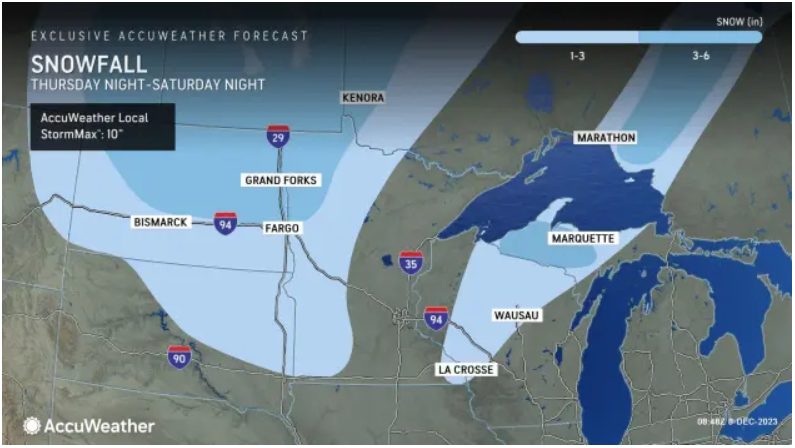
Snowfall is anticipated on the northwestern side of the low, stretching from the north-central Plains and Midwest into the Great Lakes on Saturday.
Eastern parts of the Dakotas and western Minnesota can expect 1-3 inches of snow, extending into a region from western and northern Wisconsin to the Upper Peninsula of Michigan. In both areas, there is a likelihood of a localized pocket with a snowfall range of 3-6 inches.
The prime conditions for accumulating snow are anticipated in parts of the Appalachians and the interior Northeast. This occurrence is attributed to the swift influx of cold air following a robust cold front, set to take place from Sunday afternoon into Sunday night, AccuWeather Meteorologist La Troy Thornton notes.

Storm threat in the South
This storm system poses a severe weather threat in the South. The FOX Forecast Center warns of a few severe storms potentially developing on Friday night in the Ark-La-Tex region and near the Ozarks. As moisture streams off the Gulf of Mexico, Saturday could see a more substantial threat of severe thunderstorms, including tornadoes, damaging winds, and large hail from East Texas to Louisiana, Arkansas, western Mississippi, and West Tennessee.


